
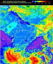
NASA LaRC is operationally generating global cloud properties products using different geostationary satellites. This Metosat-8 cloud properties products include Cloud Phase, Optical Depth, Effective Water Radius, Effective Ice Diameter, Liquid Water Path, Ice Water Path, Effective Cloud Temperature, Cloud Top Height, Effective Cloud Height, Cloud Base Height, Cloud Top Pressure, Effective Cloud Pressure, Cloud Base Pressure, Broadband Albedo, Broadband Longwave Flux, and Cloud Thickness.
Data Access
Click Here to access the Science Products. Request to use MOSDAC Single Sign On user credentials to download the data.
Data Version
- Format : NetCDF (nc4)
- CDO Version : 1.9.3 , Conventions : CF 1.6
Data Sources
- Cloud Properties Products, downloaded from LaRC, NASA
Processing Steps
https://satcorps.larc.nasa.gov/CERES_algorithms/
References
- B. A. Wielicki, B. R. Barkstrom, B. A. Baum, T. P. Charlock, R. N. Green, D. P. Kratz, R. B. Lee, P. Minnis, G. L. Smith, T. Wong, D. F. Young, R. D. Cess, J. A. Coakley, D. A. H. Crommelynck, L. Donner, R. Kandel, M. D. King, A. J. Miller, V. Ramanathan, D. A. Randall, L. L. Stowe, R. M. Welch, "Clouds and the Earth's Radiant Energy System (CERES): Algorithm overview", IEEE Trans. Geosci. Remote Sens., vol. 36, no. 4, pp. 1127-1141, Jul. 1998.
- C. Kummerow, W. Barnes, T. Kozu, J. Shine, J. Simpson, "The Tropical Rainfall Measuring Mission system (TRMM) sensor package", J. Atmos. Ocean. Technol., vol. 15, pp. 809-827, 1998
- W. L. Barnes, T. S. Pagano, V. V. Salomonson, "Prelaunch characteristics of the moderate resolution imaging spectroradiometer (MODIS) on EOS-AM1", IEEE Trans. Geosci. Remote Sens., vol. 36, no. 4, pp. 1088-1100, Jul. 1998
Derivation Techniques and Algorithm
Minnis, Patrick & Sun-Mack, Szedung & F. Young, David & W. Heck, Patrick & Garber, Donald & Chen, Yan & A Spangenberg, Douglas & Arduini, Robert & Trepte, Qing & Smith Sr, William & Ayers, J & Gibson, Sharon & F. Miller, Walter & Hong, Gang & Chakrapani, Venkatesan & Takano, Yoshihide & Liou, Kuo-Nan & Xie, Yu & Yang, Ping. (2011). CERES edition-2 cloud property retrievals using TRMM VIRS and Terra and Aqua MODIS data-Part I: Algorithms. IEEE TRANSACTIONS ON GEOSCIENCE AND REMOTE SENSING. 49. 10.1109/TGRS.2011.2144601.
Limitations
- Refer Paper
Known problems with data
- Data will be available with delay
File Naming Convention
- Following file naming convention are followed:
- NetCDF File Name (NetCDFFileName): M8SEV_DDMMMYYYY_HHMM_L2B_CP_IND_V04.0.nc
- Parameter Chip File Name : NetCDFFilename_CloudParamName(4 Char).jpg
- File Nomenclature Details:
- SatIdSensorId_AcquisitionDateTime_ProcessingLevel_ProductName_ProductRegion_Version.nc
- SatId (2 Char) = M8
- SensorId ( 3 Char)= SEV (SEVIRI sensor)
- AcquisitionDateTime (14 Char) = DDMMMYYYY_HHMM
- ProcessingLevel (3 Char) = L2B
- ProductName (2 Char) = CP (Cloud Properties)
- ProductRegion ( 3 Char) = IND (Indian Region)
- Version (5 Char) = V04.0 (Product Version Number)
| Sr. No | Core Metadata Elements | Definition |
| 1 | Metadata language | English |
| 2 | Metadata Contact | Sazid Mahammad, MRG/EPSA, Space Applications Centre (ISRO), Ahmedabad-380015, India. Email: sazid@sac.isro.gov.in |
| 3 | Metadata date | May 14, 2018 |
| 4 | Data Lineage or Quality | Depends on Metosat 8 products, some times some data gaps may be observed |
| 5 | Title | Cloud Properties Products from Meteosat-8 over Indian Peninsula |
| 6 | Abstract | NASA LaRC is operationally generating global cloud properties products using different geostationary satellites. This Metosat-8 cloud properties products include Cloud Phase, Optical Depth, Effective Water Radius, Effective Ice Diameter, Liquid Water Path, Ice Water Path, Effective Cloud Temperature, Cloud Top Height, Effective Cloud Height, Cloud Base Height, Cloud Top Pressure, Effective Cloud Pressure, Cloud Base Pressure, Broadband Albedo, Broadband Longwave Flux, and Cloud Thickness. |
| 7 | Dataset Contact | Sazid Mahammad, MRG/EPSA, Space Applications Centre (ISRO), Ahmedabad-380015, India. Email: sazid@sac.isro.gov.in |
| 8 | Update Frequency | 1 hour |
| 9 | Access Rights or Restriction | Open Access |
| 10 | Spatial Resolution | 6 Km (Nominal) |
| 11 | Language | English |
| 12 | Topic Category | Atmospheric Science |
| 13 | Keywords | Cloud Properties, Climate, cloud, cloud remote sensing, Clouds and the Earth's Radiant Energy System (CERES), |
| 14 | Date or period | From 01-May-2018 onwards |
| 15 | Responsible Party | EPSA/SAC, ISRO and LaRC, NASA |
| 16 | Organization | Space Applications Centre (ISRO), Ahmedabad, India and Langley Research Centre (NASA), Hampton, VA, USA |
| 16a | Org. role | SAC: Extraction of Indian region and generation of chips LaRC: Generation of Cloud Properties product |
| 16b | Individual name | Sazid Mahammad, MRG/EPSA, Space Applications Centre (ISRO), Ahmedabad-380015, India. Email: sazid@sac.isro.gov.in |
| 16c | Position | Scientist/Engineer, MRG/EPSA, SAC (ISRO), Ahmedabad-380015, India. Email: sazid@sac.isro.gov.in |
| 16d | Vertical Extent (minimumValue, maximumValue, unitOfMeasure, vertical datum) | Cloud top Properties |
| 17 | Geographic Extent | UL Coordinates: 38 N, 65 E. UR Coordinates: 38 S, 97.5 E. LL Coordinates: 5.5 N, 65 E. LR Coordinates: 5.5 S, 97.5 E |
| 18 | Geographic name, geographic Identifier | Indian Peninsula |
| 19 | Bounding box | UL Coordinates: 38 N, 65 E. UR Coordinates: 38 S, 97.5 E. LL Coordinates: 5.5 N, 65 E. LR Coordinates: 5.5 S, 97.5 E Number of Rows i.e. Image Height: 524 Number of Columns i.e. Image Width : 489 |
| 20 | Temporal Extent | Hourly Product with Given date, time in GMT |
| 21 | Access Rights or Restrictions | Open Access |
| 22 | Distribution Information | Online download of data files in NetCDF format and images in jpg format |
| 23 | Processing Level | Level 2 (Data product derived from Metosat-8) |
| 24 | Reference System | Projection: Geographic Latitude,Longitude; Datum: WGS84 |