
This dataset contains Integrated Water Vapor (IWV) estimates derived from GPS receivers that comprise the GAGAN TEC network. These receivers have been installed at airports at various locations in India. The Zenith Tropospheric Delay was estimated from the GPS observations using the GAMIT software. Further, IWV was estimated from the ZTD values using surface temperature and pressure from ERA-I reanalysis as additional inputs. The GAGAN-IWV estimates for 1 year – March 2013 to February 2014 – have currently been made available.
Data Access
Click Here to access the Science Products . Request to use MOSDAC Single Sign On user credentials to download the data.
Data Version
- Version 1.0 (beta)
Data Sources
- GPS receivers from GAGAN TEC Network
Processing Steps
- GAMIT software used to derive Zenith Tropspheric Delay (ZTD)
- Integrated Water Vapor (IWV) derived using procedure described in Bevis et. al. (1992)
References
- M. Bevis, S. Businger, T. A. Herring, C. Rocken, R. A. Anthes, and R. H. Ware, “GPS Meteorology: Remote sensing of atmospheric water vapor using global positioning system,” J. Geophys. Res., vol. 97, pp. 15, 787-15, 801, 1992.
- Herring, T. A., R. W. King, and S. C. McClusky. "Introduction to Gamit/Globk." Massachusetts Institute of Technology, Cambridge (2008).
- Acharya, R., M. R. Sivaraman, K. Bandyopadhyay, N. Nagori, S. Sunda, and S. Regar (2007), Ionospheric studies for the implementation of GAGAN, Ind. J. Radio Space Phys., 36 (5), 394–404.
- Sunda, S., R. Sridharan, B. M. Vyas, P. V. Khekale, K. S. Parikh, A. S. Ganeshan, C. R. Sudhir, S. V. Satish, and M. S. Bagiya (2015), Satellite-based augmentation systems: A novel and cost-effective tool for ionospheric and space weather studies, Space Weather, 13, doi:10.1002/2014SW001103.
Derivation Techniques and Algorithm
- Described in the report titled “Demonstration of GNSS-based short-range forecasting of rainfall”
Limitations
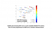
- The IWV estimates constitute a conical average of variable shape and orientation depending on the location of available GPS satellites.
Known problems with data
- No known issues at this time.
File Naming Convention
- ASCII files:
- Currently, the data for 1 year is provided in the file gagan_iwv_v1.txt
MetaData
| Sr. No | Core Metadata Elements | Definition |
| 1 | Metadata language | English |
| 2 | Metadata Contact | MOSDAC |
| 3 | Metadata date | November, 2017 |
| 4 | Data Lineage or Quality | GPS-derived Integrated Water Vapor. |
| 5 | Title | GPS-derived Integrated Water Vapor (Indian region) |
| 6 | Abstract | This dataset contains Integrated Water Vapor (IWV) estimates derived from GPS receivers that comprise the GAGAN TEC network. These receivers have been installed at airports at various locations in India. The Zenith Tropospheric Delay was estimated from the GPS observations using the GAMIT software. Further, IWV was estimated from the ZTD values using surface temperature and pressure from ERA-I reanalysis as additional inputs. The GAGAN-IWV estimates for 1 year – March 2013 to February 2014 – have currently been made available. |
| 7 | Dataset Contact | Kaushik Gopalan, GRD/AOSG/EPSA, Space Applications Centre (ISRO), Ahmedabad, 380015, kaushikg@sac.isro.gov.in |
| 8 | Update Frequency | 1 year of GPS-derived IWV is now available. Further data will be added intermittently in caches of 1 year each. |
| 9 | Access Rights or Restriction | Open Access |
| 10 | Spatial Resolution | Point data |
| 11 | Language | English |
| 12 | Topic Category | GNSS meteorology |
| 13 | Keywords | GNSS meteorology, GPS meteorology, Integrated Water Vapor |
| 14 | Date or period | March 2013 to February 2014 |
| 15 | Responsible Party | Kaushik Gopalan,GRD/AOGG/ EPSA, Space Applications Centre (ISRO), Ahmedabad-380015, India |
| 16 | Organization | Space Applications Centre (ISRO), Ahmedabad, India |
| 16a | Org. role | Geophysical parameters from satellite altimeter in the coastal region. |
| 16b | Individual name | Kaushik Gopalan, GRD/AOSG/EPSA, SAC (ISRO), Ahmedabad-380015, India. Ph: +91 79 2691 6110. Email: kaushikg@sac.isro.gov.in |
| 16c | Position | Scientist/Engineer, GRD/AOSG/EPSA, SAC (ISRO), Ahmedabad-380015 |
| 16d | Vertical Extent (minimumValue, maximumValue, unitOfMeasure, vertical datum) | NA |
| 17 | Geographic Extent | Indian Landmass |
| 18 | Geographic name, geographic Identifier | Indian Landmass |
| 19 | Bounding box | lat_min: 0N, lat_max: 30N, lon_min: 60E, lon_max: 100E |
| 20 | Temporal Extent | March 2013 to February 2014 |
| 21 | Access Rights or Restrictions | Open Access |
| 22 | Distribution Information | Online download of data files in ASCII format |
| 23 | Processing Level | Level 2 (Data product derived from raw GPS data) |
| 24 | Reference System | Datum: WGS84 |


