
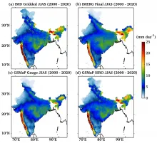
The GSMaP_ISRO is a precipitation product that was developed through the Indian Space Research Organisation (ISRO) - Japan Aerospace Exploration Agency (JAXA) Implementation of Agreement (IA) specifically for the Indian subcontinent. It is currently available from March 2000 Onwards and offers a horizontal resolution of 0.1°X 0.1° on a latitude/longitude grid with a temporal resolution of 1 hour. The dataset is based on the Global Satellite Mapping of Precipitation (GSMaP) algorithm (Kubota et al. 2020; Kumar et al. 2021, 2022) with Indian Meteorological Department (IMD) gauge correction, and is a specialized product that focuses on the Indian landmass. The GSMaP algorithm, designed by the JAXA, is instrumental in creating a comprehensive view of precipitation using microwave radiometers and cloud moving data from Geostationary Infrared (IR) technology. The algorithm is separated into three primary categories for effective measurement: the microwave imager, microwave sounder, and microwave-infrared (MVK) combined (Mega et al. 2019). A detailed verification of GSMaP_ISRO for the Indian summer monsoon periods of 2000-2020 against ground, satellite and various merge rainfall products is presented in Kumar et al. (2022).
Data Access
Science products are available to download with a Single Sign On on MOSDAC. Click Here to access the data
Data Version
- Version 1.0 (beta)
Data Sources
- GSMaP_MVK product, NOAA Climate Prediction Center (CPC) rainfall analysis, CPC Infrared brightness temperature, IMD gridded rain (0.25 degree), etc.
Processing Steps
- -For gauge adjustment, the software used was JAXA MCD_V05.02, based upon Mega et al. (2019). -Merging NOAA CPC and Indian gauges was accomplished using Matlab software. -The algorithms pertaining to GSMaP_ISRO are provided in Kumar et al. (2022) in detail.
References
- Kubota, T., Aonashi, K., Ushio, T., Shige, S., Takayabu, Y. N., Kachi, M., and Oki, R. (2020). Global Satellite Mapping of Precipitation (GSMaP) products in the GPM era. Satellite Precipitation Measurement: Volume 1, 355-373. Kumar, P., Gairola, R., Kubota, T., and Kishtawal, C. (2021). Hybrid assimilation of satellite rainfall product with high density gauge network to improve daily estimation: A case of Karnataka, India. Journal of the Meteorological Society of Japan. Ser. II, 99(3), 741-763. Kumar, P., Varma, A. K., Kubota, T., Yamaji, M., Tashima, T., Mega, T., and Ushio, T. (2022). Long-Term High-Resolution Gauge Adjusted Satellite Rainfall Product Over India. Earth and Space Science, 9(12), e2022EA002595. Mega, T., Ushio, T., Matsuda, T., Kubota, T., Kachi, M., and Oki, R. (2019) Gauge-Adjusted Global Satellite Mapping of Precipitation, IEEE Trans. Geosci. Remote Sens, 57, 4, 1928-1935.
- Kumar, P., Srivastava, S.S., Jivani, N., Varma, A.K., Yokoyama, C. & Kubota, T. (2024) Long-term assessment of ERA5 reanalysis rainfall for lightning events over India observed by Tropical Rainfall Measurement Mission Lightning Imaging Sensor. Quarterly Journal of the Royal Meteorological Society, 150(761), 2472–2488. Available from: https://doi.org/10.1002/qj.4719
Derivation Techniques and Algorithm
- The manuscript titled "Long-Term High-Resolution Gauge Adjusted Satellite Rainfall Product Over India" provides a description.
Limitations
- The number of gauge stations within a NOAA CPC pixel of 0.5 degree impacts the accuracy of the gauge-adjusted rainfall.
Known problems with data
- No known issues at this time.
File Naming Convention
HDF5 file:
Sample name : GPMMRG_MAP_YYMMDDHH00_H_L3S_MCH_03F.h5
YY - YearMM - MonthDD - DayHH - Hour
| Sr. No | Core Metadata Elements | Definition |
| 1 | Metadata language | English |
| 2 | Metadata Contact | MOSDAC |
| 3 | Metadata date | November, 2023 |
| 4 | Data Lineage or Quality | IMD gauge adjusted GSMaP_ISRO Rain |
| 5 | Title | GSMaP_ISRO Rain |
| 6 | Abstract | The GSMaP_ISRO rain data has been derived through the IMD gauge based gridded rain & NOAA CPC gauge analysis adjustment of the GSMaP_MVK rain product. It offers high-quality rainfall information with excellent spatiotemporal resolution, covering a range spanning from March 2000 Onwards. It has been developed through the ISRO-JAXA Implementation of Agreement (IA). This product provides a lat/long grid with a 0.1° X 0.1° horizontal resolution, along with hourly temporal resolution. |
| 6a | Developer | Prashant Kumar, Atul K. Varma, Takuji Kubota, Moeka Yamaji, Tomoko Tashima, Tomoaki Mega, Tomoo Ushio |
| 7 | Dataset Contact | Dr. Prashant Kumar, ASD/AOSG/EPSA Space Applications Centre, ISRO Ahmedabad-380015 prashant22@sac.isro.gov.in |
| 8 | Update Frequency | 23 years of global GSMaP_ISRO rain. Further data will be added intermittently. |
| 9 | Access Rights or Restriction | Open Access |
| 10 | Spatial Resolution | 0.1 degree |
| 11 | Language | English |
| 12 | Topic Category | Gauge adjusted satellite rainfall |
| 13 | Keywords | GSMaP_MVK, NOAA CPC rainfall analysis, CPC Infrared brightness temperature, IMD gridded rain (0.25 degree). |
| 14 | Date or period | March 2000 Onwards |
| 15 | Responsible Party | Dr. Prashant Kumar, ASD/AOSG/EPSA, Space Applications Centre, ISRO Ahmedabad-380015, India |
| 16 | Organization | Space Applications Centre (ISRO), Ahmedabad, India |
| 16a | Org. role | Development of high spatio-temporal resolution gauge adjusted satellite rainfall |
| 16b | Individual name | Dr. Prashant Kumar, ASD/AOSG/EPSA, Space Applications Centre, ISRO Ahmedabad-380015, India Email: prashant22@sac.isro.gov.in |
| 16c | Position | Scientist/Engineer - SF |
| 17 | Geographic Extent | Global |
| 18 | Geographic name, geographic Identifier | Global |
| 19 | Bounding box | lat_min: -90 , lat_max: 90, lon_min: 0, lon_max: 360 |
| 20 | Temporal Extent | March 2000 Onwards |
| 21 | Access Rights or Restrictions | Open Access |
| 22 | Distribution Information | Online download of data files in HDF5 format |
| 23 | Processing Level | Level 3 (Gauge adjusted satellite rainfall product) |
| 24 | Reference System | Datum: WGS84 |