
Data Access
Click Here to access the Science Products . Request to use MOSDAC Single Sign On user credentials to download the data.
Data Version
- Version 1.0 (beta)
Data Sources
- SMAP L-band radiometer data
Processing Steps
- Following are the three major processing steps :
- i. SMAP L1C daily data.
- ii. Import previous 3 days data
- iii. Generate global mosaic of Tb
- iv. Generate Indian mosaic of Tb
- v. Generate SWI from Tb and gridding the data
Derivation Techniques and Algorithm
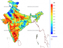
- Soil Wetness Index (SWI) is derived using a time series based methodology using SMAP L-band radiometer data, normalized to the extreme values of 0 and 1, corresponding to the dry and saturated soil wetness conditions respectively.
File Naming Convention
- The Geotiff file names follows naming convention;
- Soil Wetness Index file:
- SWI_SMAP_I_YYYYMMD1_YYYYMMD2.tif
- SWI : Soil Wetness Index
- SMAP : Soil Moisture Active Passive
- I : India
- YYYY : Year
- MM : Month
- D1 : Start Date
- D2 : End Date
- Soil Moisture file :
- SWI_SMAP_I_YYYYMMD1_YYYYMMD2.tif
- SWI : Soil Moisture
- SMAP : Soil Moisture Active Passive
- I : India
- YYYY : Year
- MM : Month
- D1 : Start Date
- D2 : End Date
MetaData
| Sr. No | Core Metadata Elements | Definition |
| 1 | Metadata language | English |
| 2 | Metadata Contact | MOSDAC |
| 3 | Metadata date | April, 2015 |
| 4 | Data Lineage or Quality | Soil Wetness Map derived using SMAP L-band Radiometer data |
| 5 | Title | Soil Wetness Index. |
| 6 | Abstract | Soil Wetness Index (SWI) is derived using a time series based methodology using SMAP L-band radiometer data, normalized to the extreme values of 0 and 1, corresponding to the dry and saturated soil wetness conditions respectively. |
| 7 | Dataset Contact | Dharmendra Kumar Pandey, Sasmita Chaurasia, EPSA, Space Applications Centre (ISRO), Ahmedabad-380015, dkp@sac.isro.gov.in, sasmita@sac.isro.gov.in |
| 8 | Update frequency | 3 day composite |
| 9 | Access Rights or Restriction | Open Access |
| 10 | Spatial Resolution | 40 km (resampled at 0.125 degrees) |
| 11 | Language | English |
| 12 | Topic Category | Land |
| 13 | Keywords | Soil Wetness Index, SMAP. SWI, Soil Moisture Active Passive |
| 14 | Date or period | April 2015 |
| 15 | Responsible Party | Dharmendra Kumar Pandey,EPSA, Space Applications Centre (ISRO), Ahmedabad-380015, India |
| 16 | Organization | Space Applications Centre (ISRO), Ahmedabad, India |
| 16a | Org. role | Geophysical parameters retrieval from satellite |
| 16b | Individual name | Dharmendra Kumar pandeyEPSA, SAC (ISRO), Ahmedabad-380015, India. Ph: +91 79 2691 4005. Email: dkp@sac.isro.gov.in |
| 16c | Position | Scientist/Engineer, EPSA, SAC (ISRO), Ahmedabad-380015, India. Ph: +91 79 2691 4005. Email: dkp@sac.isro.gov.in |
| 17 | Geographic Extent | Indian Land mask |
| 18 | Geographic name, geographic Identifier | Indian Region |
| 19 | Bounding box | lat_min: 05N, lat_max: 24N, lon_min: 68E, lon_max: 90E |
| 20 | Temporal Extent | April 2015 onwards |
| 21 | Access Rights or Restrictions | Open Access |
| 22 | Distribution Information | Online download in Geotiff format. |
| 23 | Processing Level | Level 2 |
| 24 | Reference System | Datum: WGS84 |


